U.S. Tsunami Hazard
The information presented here is based on the national tsunami hazard assessments conducted for the National Tsunami Hazard Mitigation Program by the National Oceanic and Atmospheric Administration and the U.S. Geological Survey.
Download the U.S. Tsunami Hazard Summary Fact Sheet
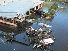 |
2009 tsunami damage in
American Samoa |
Tsunamis are infrequent high-impact events that have the potential to cause fatalities and damage on the coast. Since the beginning of the 19th century, tsunamis have caused more than 700 deaths and approximately $2 billion* in damage to U.S. coastal states and territories.
To better understand the U.S. tsunami hazard and prepare for the impacts of tsunamis on U.S. coasts, the National Tsunami Hazard Mitigation Program assessed the hazard for nine broad coastal regions. While a tsunami can strike any U.S. coast, the hazard level varies. Hazard levels reported here are qualitative and based largely on the historical record (through 2014), geological evidence, and location relative to tsunami sources, all of which provide clues to what might happen in the future.
The hazard is greatest for coastlines near subduction zones, which are particularly active seismic zones, where large earthquakes can produce damaging waves that threaten nearby and distant coasts. Dangerous subduction zones ring the Pacific Ocean and can also be found around the Caribbean.
U.S. West Coast | Alaska | Alaska Arctic Coast | Hawaii | American Samoa | Guam and Northern Mariana Islands
Puerto Rico and U.S. Virgin Islands | U.S. East Coast | U.S. Gulf Coast
U.S. West Coast: High to Very High
The West Coast states of Washington, Oregon, and California have experienced tsunamis from as far away as Alaska, South America, Japan, and Russia. The most damaging on record is the tsunami caused by the 1964 Great Alaska earthquake. More recently, harbors in the region were damaged by events in Japan (2011) and Chile (2010). Other tsunamis in the region were produced by local earthquakes and landslides (both underwater and from land). Locally, the greatest threat is from the Cascadia subduction zone, which stretches from northern California to southern Canada. Large Cascadia earthquakes occur every 500 years, on average. According to geological data in the Pacific Northwest, the last great Cascadia earthquake occurred in 1700. It produced a tsunami that crossed the Pacific Ocean and caused damage and deaths in Japan. The next Cascadia event will significantly impact the region and the nation.
Reported tsunamis: Earliest: 1812 | Total events: 94 | Events with runups above one meter: 17
Total damage: $249 million* | Total deaths: 25
Tsunamis with runups over one meter (3.28 feet) are particularly
dangerous to people and property, but smaller tsunamis also pose threats.
(Runup is the maximum elevation of the tsunami flooding on shore.) |
Alaska: High to Very High
Given its location near some of the most dangerous seismic zones in the world, a number of damaging tsunamis have affected the Pacific Coast of Alaska. Historic events include the tsunamis that devastated coastal communities in March 1964, which were produced by the largest recorded earthquake in U.S. history and associated underwater landslides. Due to Alaska's steep terrain, landslides and icefalls have also caused tsunamis in Alaska. The highest tsunami in recorded history occurred in 1958 when an earthquake-generated landslide produced a tsunami that cleared trees up to 525 meters (1,722 feet) above Lituya Bay. Volcanic activity has also caused tsunamis in Alaska as demonstrated by the Augustine Volcano in 1883.
Reported tsunamis: Earliest: 1737 | Total events: 100 | Events with runups above one meter: 22
Total damage: $731 million* | Total deaths: 222
Alaska Arctic Coast: Very Low
There are no tsunamis or significant earthquakes on record for the region, which is not seismically active and is not near a subduction zone.
| Approximately 95% of reported U.S. tsunami strikes were to Pacific states and territories. |
Hawaii: High to Very High
Hawaii has a long history of damaging tsunamis. Its tsunami record includes events caused by earthquakes both near and far. Significant tsunamis were produced locally in 1868 and 1975, but the majority of Hawaii's destructive tsunamis were produced by distant subduction zone earthquakes. Notable distant tsunamis came from Chile (1837, 1877, 1960), Russia (1923, 1952), Alaska (1946, 1957), and Japan (2011). Underwater landslides also pose a threat, and volcanic activity was responsible for a tsunami in 1919.
Reported tsunamis: Earliest: 1812 | Total events: 134 | Events with runups above one meter: 30
Total damage: $680 million* | Total deaths: 293
American Samoa: High
Historically, tsunamis in American Samoa have originated around the Pacific, but the greatest threat is from the nearby Tonga trench. This was made clear in 2009, when an earthquake near this subduction zone produced the worst tsunami in the territory's recorded history.
Reported tsunamis: Earliest: 1837 | Total events: 68 | Events with runups above one meter: 4
Total damage: $146 million* | Total deaths: 34
Guam and Northern Mariana Islands: High
Guam and the Northern Mariana Islands have been struck by tsunamis from sources both local and distant (Japan and Russia, most notably). The region's largest tsunami on record was produced by a large earthquake off Guam in 1849. The greatest threat is from the nearby Marianas trench, another significant subduction zone.
Reported tsunamis: Earliest: 1849 | Total events: 25 | Events with runups above one meter: 4 | Total deaths: 1
Earthquakes and earthquake-generated landslides caused
more than 90% of the tsunamis reported in the United States. |
Puerto Rico and the U.S. Virgin Islands: High
The U.S. Atlantic tsunami hazard is greatest for Puerto Rico and the U.S. Virgin Islands. Just to the north of the islands, in the Atlantic Ocean, lies the Puerto Rico trench, a dangerous subduction zone like those in the Pacific. However, most of the recorded tsunamis in the region were produced by local earthquakes outside of the trench, most notably in 1867 and 1918, or in the broader Caribbean region, like off the coast of Hispaniola (1842, 1946, 2010). Tsunamis caused by distant earthquakes, volcanic activity, and underwater landslides may also affect the region.
Reported tsunamis: Earliest: 1690 | Total events: 13 | Events with runups above one meter: 4
Total damage: $63 million* | Total deaths: 164
U.S. Atlantic Coast: Very Low to Low
The history of U.S. Atlantic Coast tsunamis is short, but shows that tsunamis can happen in the region. Key events include an earthquake (1886) and an underwater landslide (1964) that both produced small local tsunamis. Also, a tsunami produced by an earthquake-generated landslide off Newfoundland, Canada (1929) recorded as small waves along the U.S. coast, but caused death and destruction near its source. There is no subduction zone along the U.S. Atlantic Coast, and earthquakes are not as large or as frequent as in other regions. Underwater landslides and meteotsunamis are the most likely source of tsunami waves in the region. More distant tsunami threats come from the Puerto Rico trench, the Canary Islands, and the Azores-Gibraltar fault zone.
U.S. Gulf Coast: Very Low
Like the U.S. Atlantic Coast, the U.S. Gulf Coast is not near a subduction zone, and there has not been much tsunami or seismic activity recorded in the region. Still, evidence suggests a tsunami is possible. An earthquake off Puerto Rico (1918) produced the only tsunami on record for the Gulf Coast. However, the geography of the Gulf may reduce the impact of most distant tsunamis. Geologic evidence in the Gulf of Mexico points to underwater landslides as the region's likeliest tsunami source.
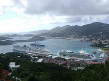 |
| Busy bay, St. Thomas, U.S. Virgin Islands |
Understanding the hazard is an important first step in understanding risk. More research remains to be done to better understand the hazard and the potential losses. These hazard levels are based on brief and incomplete historical records. Events may have been unreported or underreported or may have happened in unpopulated areas and gone undetected. The tsunami hazard exists for all coastal U.S. states and territories.
Given the large number of people who live, work, and play on the coast, even where the hazard level is low, the consequences are high. So, it is vital that we understand these consequences as well as how to prepare for and respond to tsunamis, both local and distant and big and small.
*All dollar figures adjusted for inflation (December 2018)
More Information:
February 2019
|